AI and Earth Observation: Apply AI to satellite data for sustainability, biodiversity and climate adaptation
Secure up to €50,000 in EU funding via the FIERCE programme.
We support you from first idea to working pilot.


AI and Earth observation, within reach
Earth observation data – satellite imagery, multispectral sensors, radar – is now open and accessible. AI is what turns that data into something a non-specialist team can act on. Together, AI and Earth observation are how municipalities, research institutes, companies and NGOs measure biodiversity, monitor reforestation, prioritise climate-adaptation work and verify sustainability claims.
This is not about space. It is about better decisions on Earth. AI applied to satellite data reveals changes in soils, water bodies and vegetation, identifies supply chain risks, prioritises land for restoration or infrastructure, and makes the energy performance of buildings visible.
Economies can be steered more precisely, cities can be planned for climate resilience, infrastructure can be monitored, and humanitarian operations as well as disaster response can be better coordinated. The combination of Earth observation data and AI is what makes this practical at the scale of a single project team. Read more about specific applications: Earth Observation for Sustainability and Earth Observation for Agriculture.

Spot opportunities and seize them: Which space-tech solutions align with your mission?
Many organisations underestimate how easily they can now access technologies, expertise and funding sources that were previously available only to a few.
What has been missing is clear guidance: Which space-tech solutions truly align with your mission? How can entry be supported, financed and developed in partnership? This is precisely where N3XTCODER steps in.


44 use cases demonstrating how space tech is already making an impact on Earth
To make space technologies tangible, it helps to look at concrete applications. The following 44 use cases illustrate where space tech is already contributing to the green and digital transformation, and how organisations are already benefiting from these opportunities.
Nature & Ecosystems
- Assess biodiversity: Satellites reveal which habitats are species-rich and where they are under threat.
- Measure carbon storage: Vegetation data makes it possible to see how much CO₂ forests, peatlands or seagrass meadows can capture and store.
- Monitor reforestation areas: Planting projects can be tracked and verified remotely, without the need for constant on-site presence.
- Detect invasive species: Sudden appearances of plants or pests can be identified early, before they threaten ecosystems.
- Identify illegal logging: Hidden deforestation can be detected and pursued by authorities.
- Prioritise land for conservation: Data helps pinpoint areas most suitable for acquisition, restoration or protection.
- Detect vegetation stress: Drought stress or nutrient deficiencies become visible before damage becomes irreversible.
- Quantify blue carbon: Mangroves and coastal ecosystems can be evaluated for their carbon storage potential.
Image: Biodiversity Hotspots in the Okavango Delta by Sylva (Germany)

Agriculture & Food
- Predict pest risks: Satellites reveal stress signatures in crops before infestations become visible.
- Monitor crop growth: Data on leaf area, chlorophyll and water status supports yield forecasts.
- Target fertilisation: Variable-rate maps help apply fertiliser or seeds only where needed.
- Plan irrigation efficiently: Water usage can be aligned with actual soil and plant requirements.
- Optimise soil sampling: Vegetation and soil signatures make targeted sample collection easier.
- Optimise harvest timing: Temperature and growth data help predict the best harvest windows.
Image: Crop Monitoring by DynaCrop (Czech Republic)

Forestry
- Classify tree species: Multispectral analyses reveal which tree species dominate in which regions.
- Assess wildfire risks: Temperature and vegetation data support planning and prevention measures.
- Detect drought and water stress: Forests can be monitored at scale for vitality and climate-related damage.
- Identify forest pests: Canopy damage and stress patterns enable early detection.
- Monitor forest areas long-term: Forest management can be tracked remotely over decades.
Image: Tree species classification for Germany by Geo Engine GmbH (Germany)

Water & Disaster Response
- Map flood-prone areas: Heavy rainfall or flooding reveals which areas are affected.
- Monitor water resources: Surface water, groundwater and river regimes can be analysed spatially and over time.
- Predict droughts: Vegetation and soil moisture provide early indicators of extreme dry periods.
- Simulate hydrological scenarios: Models help assess risks more accurately and plan protective measures.
Image: Flood assessment in Morocco by Space4Good (Netherlands)

Energy & Sustainability
- Identify rooftop potential: Roofs can be analysed automatically for suitability for solar panels or green roofs.
- Optimise wind and solar farms: Vegetation, soiling and shading affect energy yield and can be assessed remotely.
- Visualise building energy efficiency: Thermal imagery at night reveals where energy is being lost.
Image: Roof Potential Map for Rotterdam by Space4Good (Netherlands)

Climate & Sustainability Compliance
- Verify carbon credits: Nature-based climate projects can be measured and validated.
- Assess nature-based projects: Restoration strategies, such as reforestation or rewetting, can be monitored.
- Prioritise land areas: Data helps identify regions most suitable for acquisition, restoration or protection.
- Identify supply chain risks: Deforestation, water scarcity or land-use change become visible early.
- Automate regulatory reporting: Data facilitates ESG, CSRD or sustainability reporting.
Image: Land Acquisition Prioritization in North Carolina by Sylva (Germany)

Urban & Society
-
Map urban trees: City trees can be counted, categorised and assessed for vitality.
-
Analyse urban heat islands: Thermal data shows where cities overheat and where interventions are needed.
-
Visualise light pollution: Festivals, research and conservation benefit from precise data on nocturnal light.
Model urban climate: Temperature, vegetation and building density inform climate adaptation and urban planning.
-
Manage tourism impact: Satellite and Earth observation data help monitor and manage tourism effects on local ecosystems, making changes in vegetation, coastal zones, pathways or sensitive natural areas visible.
Image: Heat Islands Analysis of Milano by constellr (Germany)

Infrastructure, Construction & Geotechnics
- Measure settlements and deformations: Infrastructure such as bridges, tunnels or dams can be monitored with millimetre precision.
- Monitor archaeological sites: Satellite imagery allows historic structures — temples, tombs or pyramids — to be monitored for settlement, erosion or structural changes without invasive interventions.
- Detect landslides: Unstable slopes can be identified before damage occurs.
- Monitor mining operations: Subsidence and deformations over minefields become visible and manageable.
- Construction site monitoring: Data supports cost control, risk management and project execution.
Image: Giza Pyramids Monitoring by Astro42 (England)

Humanitarian Aid & Geopolitics
- Conduct post-conflict assessments: Infrastructure, damage and hazards can be documented from orbit.
- Coordinate refugee camps: Supply, water and energy needs can be planned without being on-site.
- Monitor sanitation infrastructure: Provision in camps or projects can be verified remotely.
- Track land-use changes: Conflicts or crises leave patterns that can be observed from afar.
Image: Latrine Infrastructure Monitoring in Uganda by Space4Good B.V. (Netherlands)

European Funding for SMEs: The FIERCE Programme
Turning potential use cases into real solutions and pilot projects requires access to funding, expertise and partners.

Through the FIERCE programme, the EU supports small and medium-sized enterprises (SMEs) and startups across Europe in integrating space technologies into sustainable business models and leveraging the green and digital transformation.
As an official EU FIERCE service provider, we enable SMEs and startups to fund our support through EU FIERCE resources, helping them take space-tech projects from concept to implementation quickly and with financial backing.
Programme duration: 2024–2027
Funding for up to 70 SMEs, startups and scaleups: Up to €50,000 per project
Developing Green Solutions
FIERCE targets SMEs and startups that want to leverage space technologies to develop new green solutions or enhance existing ones. The programme funds collaboration with external service providers who can help design, scale or bring space-tech-based products, services or processes to market readiness.
At the heart of FIERCE are so-called “green solutions” — products, services or processes that use space-tech data such as Earth observation (EO), remote sensing or satellite navigation to reduce the ecological footprint of a company or its users. This impact can be achieved directly within the organisation (for example, through more efficient use of resources, energy or raw materials) or indirectly through new offerings that enable improved environmental or climate outcomes.

Application Process
How to apply for FIERCE
- Register on the Onepass application platform.
- Request service and cost proposals via the Service Provider Catalogue
- Submit your application including the proposals from your chosen service providers.
Considering applying or need help preparing your application?
Book a 20-minute video call with our co-founder and CEO, Simon Stegemann, and learn how we can support you throughout the application process.

Space Tech Meetup in Berlin
Starting in February, N3XTCODER will host the Space Tech Meetup at Spielfeld Digital Hub Berlin. Our meetup is the ideal first point of contact for organisations interested in the FIERCE programme and keen to explore the potential of space technologies.

The exclusive format is intentionally limited to around 30 participants to enable peer-level exchange, advice and networking.
In inspiring sessions, we present concrete use cases demonstrating how space technologies are already being applied on Earth.
At each meetup, official EU FIERCE service providers showcase their offerings, which can be funded through the programme and utilised for pilot projects.
The meetups are scheduled to align with the FIERCE programme application windows. After each meetup, there are at least six weeks until the application deadline — providing ample time for thorough preparation and submission.
Highlights from our first Space Tech Meetup
Our first Space Tech Meetup gathered 30 attendees at Spielfeld Digital Hub. Simon Stegemann opened with Nobel laureate Yunus's message: stop accepting the status quo. Annabel Egert (Novaspace) showed that 67% of companies feel ready for the green transformation, yet only 14% utilise free EU satellite data. Jonathan Moore presented "Hakuryu", an art project transforming satellite data into music. Daria Stepanova (AIRMO) discussed her work as a rocket scientist developing LiDAR sensors for methane tracking. Florian Spathelf introduced additional funding opportunities through the Forschungszulage and ZIM programme, both covering internal personnel costs. The next meetup is scheduled for May 2026, timed for the upcoming FIERCE application round.

Webinar: From Idea to €50,000 Funding for Your Space Tech Project
You have until 31.03.2026 to apply for up to €50,000 in FIERCE funding. On 6 March, we are hosting a webinar showing you how to turn your idea into a compelling FIERCE application. With real use cases, practical services and all the details of the process. Join us and get started.
Solution Providers
Our 44 Space Tech use cases come from official EU-FIERCE service providers. We invite a selection of these providers to each meetup and our accompanying webinar.
CASSINI Hackathons
In addition to our Space Tech Meetup, the biannual CASSINI Hackathons organised by the European Commission offer another low-threshold entry point into the space-tech sector.
The hackathons focus on rotating themes that address the EU’s sustainability and digitalisation goals. For several years, N3XTCODER has been part of this ecosystem, actively shaping the formats in Germany.
The hackathons link Europe’s space infrastructure with real-world challenges from business, society and the environment. Organisations can submit their own challenges, which are tackled by interdisciplinary teams of developers, designers and data scientists and transformed into initial solution concepts.

N3XTCODER has organised over 25 hackathons
〰️
Take a look at some of our past CASSINI Hackathons:
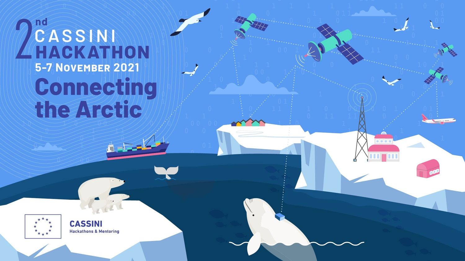
At the 2nd CASSINI Hackathon, “Connecting the Arctic,” in November 2021, we brought the pan-European competition to Berlin. With European support, participants at Spielfeld Digital Hub developed solutions to protect sensitive ecosystems, in collaboration with WWF Germany and LT&C
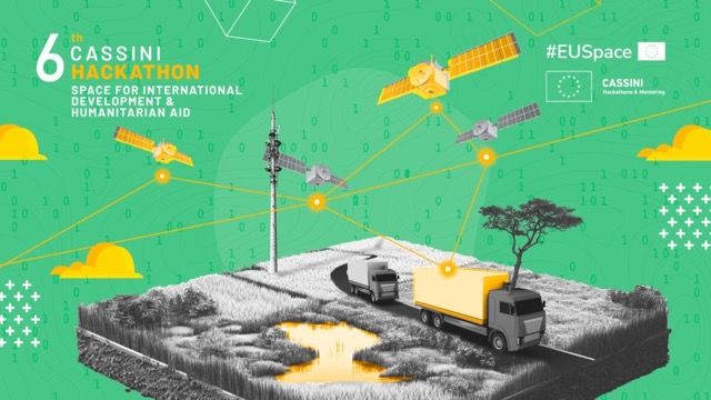
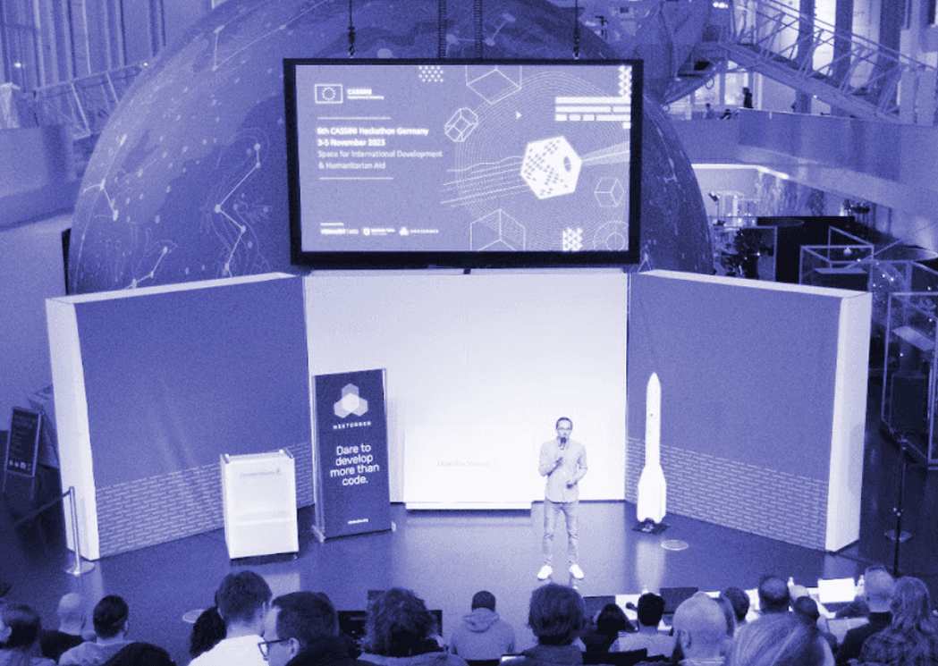
Space for International Development & Humanitarian Aid
The 6th CASSINI Hackathon in Munich used EU open-source Earth observation data for humanitarian aid and international development. Over 80 experts worked at the Deutsches Museum on digital tools for humanitarian and development applications.
The 10th CASSINI Hackathon in November 2025 brought together developers, designers, data scientists and students from across Europe to create solutions using Copernicus, Galileo and EGNOS data in tourism, gaming, sports and society.
Why N3XTCODER for AI and Earth Observation
We are an AI agency with a decade of impact-tech experience and over 160 AI projects since 2019. We combine the engineering depth that production AI needs – RAG, vector search, EU-hosted infrastructure, mandatory human review – with the EU funding access and Earth-observation network we have built through FIERCE and CASSINI. That combination is rare: most space-tech firms cannot ship AI, and most AI agencies have no foothold in Earth observation. Our mission stays the same: tech with purpose, tech for good.
- 160+ AI projects since 2019, including production AI for the German Insurers Association (GDV), Evangelische Bank, Kompetenzz and Mother Earth AI
- 25+ hackathons organised since 2016, including 5 years as part of the CASSINI Hackathons
- 10,000+ participants at more than 200 impact events
- Official service provider in the EU FIERCE programme

Get in touch and discover how space technologies can transform your organisation
Simon Stegemann
Co-Founder and CEO

Schedule a Video Call

Join a 20-minute video call with our co-founder and CEO, Simon.

Receive personalised recommendations for your next steps.